Tuesday, March 31, 2015

Ilocos Norte, Philippines


Tourist Attractions
Kapurpurawan Rock Formation
Kapurpurawan Rock Formation is situated in Burgos, Ilocos Norte. From the national highway, one will traverse a long winding dirty road. No public transportation goes inside the area so it is a must to have your own car rather than walking under the heat of the sun.

Due to its white color characteristic, its name was derived. In Ilocano word, "Puraw" means white. The rock looked like a large dragon, watching over the entire coast. Once you reach it, you will enjoy watching its natural beauty as this is created by the waves of the ocean for so many years.

Paoay Lake is locally called dakkel danum. What makes Paoay Lake Legendary? It is because of the interesting and enchanting history narrated by forefathers and passed upon to the present, including the other stories or observations that happened in the lake narrated by te residents nearby.
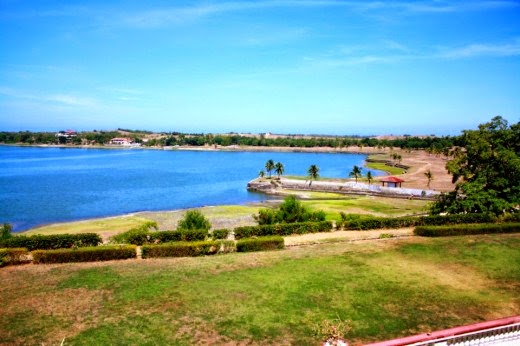
Paoay Lake
According to such legendary account, Paoay Lake was formed as a punishment to the early settlers thereat who used to be immensely religious but turned wicked and preoccupied by material things later. Their wicked acts earned the ire of their gods, thus submerged the place, turning it into a body of water, while the people were made into fishes with their fancy adornments, such as jewelries, still attached with them. These stories say that, seated in Paoay Lake’s location was a group of three villages called Gumura, Siduma and Sintapuli. The first two villages were much like those communities, Sodom and Gumorrah, which according to the Holy Bible, were submerged in water as a form of punishment by God to the People who turned wicked.

Ilocos Norte is one of the provinces of the Philippines located in the Ilocos Region in Luzon. Laoag City is the capital of the province. It consists of 1 city and 22 municipalities. Ilocos Norte is located in the northwest corner of Luzon Island. Bordering the province are Cagayan and Apayao in the east; and Abra and Ilocos Sur to the south. Ilocos Norte faces the South China Sea to the west and Luzon Strait to the north.

Ilocos Norte is noted for being the birthplace of former President Ferdinand E. Marcos, who declared Martial Law and led an authoritarian rule over the country during the latter half of his incumbency. The Marcoses enjoy a degree of popularity in the province. 

Before the coming of the Spaniards, Ilocos Norte was known to trade with nearby Chinese and Japanese merchants. The region had plenty of gold, so the merchants from Japan and China would often visit the area to trade gold with beads, ceramic and silk. The inhabitants of the region were believed to be of Malay origin and they called their place samtoy, from “sao mi toy”, which literally meant “our language.” 

The Ilocano legacy and life can be described as “the browbeaten, industrious, cheerful, simple people who have shown a remarkable strain of bravery and a bit of wanderlust.” The present day Ilocanos searched for greener pastures in new lands, both local and foreign. The Ilocano material culture and spirituality can be seen in the past images of Spanish saints, antique but intricate wooden furniture and quality local fiber. The Ilocano cuisine ranges from the exotic “abu-os” or ant eggs to vegetable broth “dinengdeng”, the sticky “tinubong” to the “poqui-poqui” or eggplant salad. 

Majority of the inhabitants of the province are Roman Catholic although several other religious sects have strong followers in the area. The most notable is the Aglipayan Church, founded by Batac native Gregorio Aglipay. Ilocos Norte is home to several famous Roman Catholic churches. Among these are: Paoay Church named as a UNESCO World Heritage Site in 1993; St. William’s Cathedral in Laoag which is famous for its Sinking Bell Tower; St. Monica Church, the biggest church in Ilocos Region; and the Baracca Church. 

The major industries in Ilocos Norte are agriculture, fishery, livestock such as swine and cattle, cottage industries such as weaving, furniture making, ceramics and iron works; tourism and pottery. Food processing also contributes to the economy of the province. Salt, empanada, bagoong, basi which is a native Ilocano wine, vinegar, longganisa, chicharon and bagnet are some of the foods that are processed in the province. Ilocos Norte’s position in the northwest corner of Luzon makes it ideal for wind power generation. Currently, there is a 25 Megawatt wind farm in Ilocos Norte, and several wind energy projects are being planned.

Ifugao Province, Philippines


Tourist Attractions
Banaue Rice Terraces
Banaue Rice Terraces are 2,000-year-old terraces that were carved into the mountains of Ifugao in the Philippines by ancestors of the indigenous people. The Rice Terraces are commonly referred to by Filipinos as the "Eighth Wonder of the World." It is commonly thought that the terraces were built with minimal equipment, largely by hand. The terraces are located approximately 1500 metres (5000 ft) above sea level. They are fed by an ancient irrigation system from the rainforests above the terraces. It is said that if the steps were put end to end, it would encircle half the globe.

Banaue Rice Terraces
Locals to this day still plant rice and vegetables on the terraces, although more and more younger Ifugaos do not find farming appealing, often opting for the more lucrative hospitality industry generated by the terraces. The result is the gradual erosion of the characteristic "steps", which need constant reconstruction and care. In 2010, a further problem was drought, with the terraces drying up completely in March of that year.

Ifugao is a landlocked province of the Philippines located in the Cordillera Administrative Region in Luzon. The province covers a total land area of 262, 820 hectares which is subdivided into 11 municipalities. Ifugao is located in a mountainous region characterized by rugged terrain, river valleys and massive forests. Its capital is Lagawe and borders Benguet to the west, Mountain Province to the north, Isabela to the east, and Nueva Vizcaya to the south.

Ifugao was formerly a part of the old Mountain Province. It was created as an independent province on June 18, 1966 by virtue of Republic Act No. 4695. The name of the province was derived from the word “i-pugo”. Pugo means “hill” while the prefix “i” means “from”. The Spaniards changed “Ipugo” to “Ipugaw”, and it was finally changed by the Americans to “Ifugao.”

Ifugao are the majority of the population of the province comprising about 67.9%. Other ethnic groups living in the province are the Ilocanos with 13.7%, Ikalahan with 8.6%, Ayungon with 6.2% and Kankana-ey with 0.6%. 

For the Ifugaos, custom is the basis of all laws and these customs are often supported by ancestry knowledge. One of the most basic principles of Ifugao culture is: “We cannot but do what our ancestors told us.” They have some customs and rituals that seem rather strange to the Western observers. In some areas, for instance they do not bury the dead. Instead they wrap them in cloth and hang them in trees where they drip during decomposition. Once the body has been reduced to a skeleton it is wrapped in what is called a death blanket and kept under the eaves of the hut. 

Ifugao culture revolves around rice, which is considered a prestige crop. There is an elaborate and complex array of rice culture feasts linked with taboos and agricultural rites from rice cultivation to rice consumption. Harvest season calls for extravagant thanksgiving feasts, while the concluding harvest rites “tungo” or “tungul” (the day of rest) entail a strict prohibition of any agricultural work. Partaking of the rice beer (bayah), rice cakes, and betel nut is an indelible practice during the festivities and ritual activities. 

The Banaue Rice Terraces are the main tourist attraction in the province. These 2000-year-old terraces were carved into the mountains, without the aid of machinery, to provide level steps where the natives can plant rice. In 1995, they were declared a UNESCO World Heritage Site.

Sunday, March 29, 2015

Guimaras Province, Philippines


Tourist Attractions
Roca Encantada
Roca Encantada was built in honor of Doña Presentacion Hofileña Lopez in 1910. It was then the summer home of the Lopez clan. Roca Encantada was declared by National Historical Institute as a National Heritage House on August 14, 2002. It is found in the town of Buenavista in Guimaras.

Alubihod Bay
Alubihod Bay is the most well-known white beach and boasts a very nice beach – almost similar to Boracay quality. The sand is just a little less white and not so powdery. But the beach is still stunning, even during rainy season!

The waters are clear blue and you can swim to the surrounding smaller islands or take an outrigger boat for island hopping.

Isla Naburot
There is a Coin Videoke box and cheap drinks are offered also.

Isla Naburot in Sinapsapan, Jordan. Island has rich colorful marine life, visible and exotic sealife; special berth for lovers; tranquil hideaway for soothing tense nerves; has 8 native styled cottages; ideal for fishing, boating, swimming, snorkeling, island hopping and scuba diving.
Tiniguiban Islet

Tiniguiban Islet in Pulang Pasayan, Igang, Nueva Valencia. A haven of scuba divers.

Guimaras is an island province of the Philippines. It is the youngest and smallest of the six component provinces of the Western Visayas Region. The island is located in the Panay Gulf, between the islands of Panay and Negros. To the northwest is the province of Iloilo and to the southeast is Negros Occidental.

Guimaras is composed of five municipalities, namely: Jordan, the provincial capital; Buenavista; Nueva Valencia; and the newly created Sibunag and San Lorenzo. It occupies about 3% of the region’s total land area. The inhabitants of Guimaras are considered as Guimarasnon. Hiligaynon and Kinaray-a are the native dialects as it was once a sub-province of Iloilo. It has dry and wet season. 

Formerly known as Himal-us, Guimaras first gained its status as a sub-province of Iloilo by virtue of Republic Act 4667, which was enacted on June 18, 1996. It was made an independent province on May 22, 1992. Originally, Guimaras is composed of 3 municipalities. In 1995, by virtue of R. A. 7986 and R.A. 7897, the municipalities of Sibunag and San Lorenzo were created in the province. The island suffered an ecological disaster in August 2006 when a chartered oil tanker, M/T Solar 1, carrying 2.4 million liters of oil sank 17 kilometers off the coast. About 1000 hectares of mangrove forests were affected, including parts of Taclong Island Sanctuary, a feeding and breeding ground for fish and other species. 

The province is basically agricultural with palay, coconut, mango, vegetables, livestock, poultry and fishing as major products. Its major industries are tourism, fruit processing, coconut processing, fish farming, handicrafts making, mining, quarrying and lime production. 

The Guimaras Island is famous for producing the sweetest mangoes in the world. Some 50,000 mango trees are planted in 8000 hectares plantation managed by corporations and individual growers. The 3 major plantations in the province are Oro Verde, Buenavista; Southern Orchard, Jordan; and Guimaras Tree Farm, Buenavista. The variety of mangoes produced is also best for making dried mangoes, jam and other delicacies. The Mango Festival is a yearly celebration of the province which showcases the local culture and products of the province. 

Guimaras is blessed with natural and historical attractions. Clear blue waters, white sand and marine life rivals that of Boracay. Commonly visited ones are Roca Encantada, Alubihod and Puerto del Mar. Other natural attractions in the island are its falls, springs, off-shore islets, coves and caves.

Friday, March 27, 2015

Eastern Samar Province, Philippines


Tourist Attractions
HOMONHON ISLAND
HOMONHON ISLAND
HOMONHON ISLAND
Location: Southeast of Guiuan, 60 nautical miles from Tacloban.
Description: Tiny island where Ferdinand Magellan and his men first set foot on Philippine soil on March 16, 1521; viewing of the historic Magellan plaque/marker.

SULUAN ISLAND
SULUAN ISLAND
Location: Guiuan, Eastern Samar.
TUBABAO ISLAND
Description: The First Filipinos who made contact with Magellan lived here.

TUBABAO ISLAND
Location: Guiuan, Eastern Samar.
Description: Where the White Russians of the IRO (International Refugee Organization) stayed immediately after World War II.

KANTICAN ISLAND
KANTICAN ISLAND (PEARL ISLAND)
Location: Guiuan, Eastern Samar.
Description: It is a pearl culture farm; haven of rich marine life such as lobsters, shells, fishes, abalones, corals; clear blue waters and immaculately white coral beach; perfect site for scuba diving, fishing and swimming.

DIVINUVO ISLAND
DIVINUVO ISLAND
Location: A 3-sq. kilometer island in Brgy. Lalawigan, Borongan.
Description: It has a crystal-clear water, white beach, swaying palm trees, multi-colored fishes and corals beneath; best suited for scuba diving and swimming.

HAMORAWON SPRING
HAMORAWON SPRING
Location: At the heart of the town of Borongan.
Description: A natural spring said to be miraculous. This spring as the Boronganons say, is full of legend that whoever takes a bath in this cool spring especially foreigners, will surely go home with a Boronganon wife. Around this spring is Spanish built stone wall.

Eastern Samar is a province of the Philippines located in the Eastern Visayas Region. It is bounded on the east by the Philippine Sea, on the west by the province of Samar, on the south by Leyte Gulf and on the north lies Northern Samar. The province is subdivided into 22 municipalities and 1 city. Borongan City, the provincial capital, is the largest in terms of area. Eastern Samar is the 20th least populated province in the Philippines.

The province of Eastern Samar was created by Republic Act No. 4221 which was approved by the Congress on June 19, 1965. This Act divided the whole island of Samar into three independent provinces namely: Northern Samar, Eastern Samar and Western Samar which was subsequently renamed as Samar.

Before its existence as an independent province, places which are now part of Eastern Samar played important roles in the history of the country. On March 16, 1521, Magellan first set foot on Philippine soil in the island of Homonhon which he called as “The Watering Place of Good Signs”.

The climate of the province is characterized by rain and marked seasonal period of heavy rain at all months of the year. It has also distinct seasons: rainy from November to January and dry from July to September.

Agriculture is the major source of income in Eastern Samar. The main product of the province is copra. Other local agricultural products include maize, rice, sugarcane and various other vegetables.

The province has one of the largest remaining unfragmented tracts of lowland tropical rainforests in the Philippines. In these dense jungles, some endangered animals can be found like the Philippine Eagle which is the second largest eagle in the world, the Philippine Cockatoo and the Flying Lemur. One can explore these rainforests by taking a local boat ride in one of the several rivers or hike on the slowly rising trails following the river to one of the waterfalls. Undeveloped beaches also abound when you feel like relaxing or taking a break from your vigorous adventures.

Eastern Samar is one of the last natural paradises in the Philippines. So if you are planning to take a trip to the Philippines and looking for more undeveloped and natural destinations, include Eastern Samar in your itinerary because a fantastic experience awaits for you in the province.

Tuesday, March 24, 2015

Dinagat Island Province, Philippines


Tourist Attractions
Lake Bababu
Lake Bababu is located in the municipality of Basilisa. The lake got its name from the Bisaya phrase 'Baba ng Buaya" which means 'mouth of crocodile'. Whether this name came from a crocodile mouth-shaped rock formation or there used to have crocodiles living here is still undetermined. This has an underwater channel connected to the sea, thereby feeding the lake with saltwater from below while fresh water at the top remains uninterrupted.
Isla Aga
Isla Aga. At one end of this tiny island lies a broken hanging bridge which provides an excellent view of the sea and the surrounding islands. You can never possibly stop yourself from having a dip in the crystal clear water enclosing Isla Aga. Its beach was just too alluring to resist.

Bitaog Beach
Bitaog Beach is located in an island that is part of the municipality of Basilisa, Dinagat Islands. The powdery white sand of Bitaog Beach offers more than just its beautiful shore line. The blue colored water is perfect for snorkelling and other water activities. Aside from the white sand beach, there are also a lot of large rock formations and limestone peaks to see.

Bonsai Forest in Loreto
Bonsai Forest can be found at Mt. Redondo in the town of Loreto. It is a distinctive forest where uncommon bonsai plants grow abundantly. It is renowned as the province's major tourism icon.

PBMA Shrine
Philippine Benevolent  Missionaries Association (PBMA) Shrine, also known as the holy land. Dinagat Islands is the home of the organization and the town of San Jose serves as its center. PBMA is a SEC registered, legitimate, non-sectarian, non-profit, , humanitarian and a brotherhood organization founded by its divine master Ruben Edleo, Sr. in 1965. Majority of the people in Dinagat are members of the said roganization and the shrine is where Ruben Ecleo, Sr’s body rest. To those who want to go inside the shrine, just first ask permission.

Kisses Islets
Kisses Islet located in Libjo has tiny charming limestone formations in the middle of the sea. 

Lalaking Bukid - Rock Formation
Lalaking bukid" wich means "Mens mountain". The locals name it like that because when you look at the shape, its like a men who is laying on his back. It is located in Basilisa of the said province. 

Dinagat Islands is the 81st and the newest created province of the Philippines. It is located on the southern side of Leyte Gulf. It is bounded on the east by the Philippine Sea, on the south by Gaboc Channel and Nonoc Island; and on the west by Surigao Strait. Its main island, Dinagat, is about 60 km from north to south. The highest points of the province are Mt. Kambinliw and Mt. Redondo, found in the northern and southern part of the municipality of Loreto.

The province of Dinagat is composed of 7 municipalities with Loreto as the largest municipality and Dinagat as the smallest municipality in terms of land area. San Jose is the capital of the province and is where the headquarters of the Philippine Benevolent Missionaries Association, Inc. (PBMA) is located. PBMA is a non-sectarian organization bounded by a strong spirit of brotherhood which was founded by Ruben Edera Ecleo Sr. in 1965. 

Dinagat Islands was once a part of the First District of the province of Surigao del Norte. But with the approval of Republic Act 9355, otherwise known as the Charter of the Province of Dinagat Islands, it became an independent province on December 2, 2006. On February 11, 2010, the Supreme Court of the Philippines declared the creation of Dinagat Islands Province null and void on grounds of failure to meet the land area and population requirements for the creation of local government units. The province then reverted to Surigao del Norte. However last March 30, 2011, the Supreme Court amended its previous ruling and upheld the constitutionality of RA 9355 and the creation of the province of Dinagat Islands. 

The climate of the province is characterized by no pronounced dry season but with a very pronounced maximum rainfall period from November to January. Cebuano, Surigaonon, Boholano, Tagalog and Waray are the major dialects spoken in the province. 

Dinagat Islands is rich in metallic and non-metallic mineral resources. These include chromite which is most abundant in the municipality of Loreto, aluminous laterite ore and nickeliferous laterite. Other minerals such as rock phosphate, limestone, siliceous and gold deposits are also scattered in small amounts across the island. 

The province is also blessed with natural wonders which are popular among tourists who visit the province. The Mt. Redondo Natural Bonsai Forest covers an estimated area of more than 100 hectares of century-old “Bonsai” forest. The Ouano Lagoon is ideal for swimming with its deep-bluish and clear water. Other places of interest in the province are the surf site of Campijagit Point, the Blue Lagoon at Libjo, Lake Bababu at Basilisa and the Bitaug and Sundayo Beaches.

Friday, March 20, 2015

Davao Oriental, Philippines


Tourist Attractions
A typical form of a natural 
bonsai tree
Davao Oriental is a province of the Philippines located in the Davao Region in Mindanao. It is the easternmost province of the Philippines with Pusan as the easternmost point. The province borders Compostela Valley to the west, and Agusan del Sur and Surigao del Sur to the north.

Davao Oriental was created in the year 1967 by virtue of Republic Act No. 4867. It is subdivided into 10 municipalities and 1 city with Mati City as the provincial capital. 

Aliwagwag Falls, Barangay 
Aliwagwag, Cateel
The inhabitants of Davao Oriental are natives and immigrants from other provinces and the Mandaya Tribe is the most dominant tribe in the province. The dialects used in the province are Dabaweño, Tagalog, Cebuano, Visayan and English language. The province has short dry season and pronounced rainy season. Rainy season occurs during the months of November to January. 

Davao Oriental’s top investment industries are coconut and mango production. It is the copra (dried coconut meat) producer capital of the Philippines. The province is also noted as one of the top producers of good quality rice varieties and hybrid rice seeds in the Philippines. Wood processing and mining industry provide new investment opportunities in the province. Davao Oriental is also into abaca and rattan production, as well as producing bricks and marble. 

Altar Cave San Agustin - 
Pusan Point
Davao Oriental is rich in culture. The Mandaya Tribe is famous in the province because of their various customary rites and colourful clothes. Mandaya children aging from 10 to 12 years old also has a traditional rite of blackening their teeth by chewing habitually tobacco pellets moistened with the juice of ammong vine. Tourists can also see how the tribe weaves “dagmay” or Mandaya cloth in Mandaya Village located in Barangay Pichon, Caraga. 

Unlike other ultramafic forests in the 
Philippines, Mount Hamiguitan has 
several special and unique species 
of century old miniature trees.
Another tourist destination in Davao Oriental is the Aliwagwag Falls which is located in the middle of the forest at Barangay Aliwagwag, Cateel. This is considered as one of the most beautiful waterfalls in the country. It has a series of 84 cascading falls appearing like stairway to the sky in various heights. Pusan Point, on the other hand, is the place where the first sunrise in the Philippines can be seen. 

Other tourist destinations in the province are the Bonsai Forest and the Menzi Tourism Complex. 

Davao Oriental is also the home of various festivals. Among these are the Banayan and Bauldayawan Festivals which are held every 3rd week of October and June, respectively. These festivals are celebrated as thanksgiving for bountiful harvest among the people of the municipalities. It showcase trade fairs, street dancing and cultural presentations.

Wednesday, March 18, 2015

Davao del Sur Province, Philippines


Tourist Attractions
Mount Apo
Mount Apo is a large solfataric, potentially active stratovolcano in the island of Mindanao, Philippines. With an elevation of 2,956 metres (9,698 ft) above sea level, it is the highest mountain in the Philippine Archipelago and is located between Davao City and Davao del Sur province in Region XI and Cotabato province in Region XII. The peak overlooks Davao City 45 kilometres (28 mi) to the northeast, Digos City 25 kilometres (16 mi) to the southeast, and Kidapawan City 20 kilometres (12 mi) to the west.

The first two attempts to reach Mt. Apo’s summit ended in failure: that of Jose Oyanguren (1852) and Señor Real (1870). The first recorded successful expedition was led by Don Joaquin Rajal in October 10, 1880. Prior to the climb, Rajal had to secure the permission of the Bagobo chieftain, Datu Manig. It is said that the Datu demanded that human sacrifice be made to please to god Mandarangan. Fortunately, the datu agreed to waive this demand, and the climb commenced on October 6, 1880, succeeding five days later. Since then, numerous expeditions followed. These and more are described in colorful narrations by Fr. Miguel Bernad, S.J. On May 9, 1936, Mount Apo was declared a national park by President Manuel L. Quezon. A note on the etymologies: Mt. Apo is said to be named after a nobleman named Apong, who got killed while mediating the battle between two suitors of his daughter Saribu. Another proposed origin of the name is from the word Apo itself, which in Filipino tongues means “master” or “grandfather.” 
Olanivan Island Small Island

Olanivan Island Small Island with the white seashores, clear water and rare corals.

Piape Reef
Piape Reef (Pdada) which is covered with a variety of corals. The area is submerged during the high tide and visible during the low tide. The depth of tubulan Cove in Malita is ideal for scuba diving while the surface is an invitation to water skiers.
Tudaya Falls

Tudaya Falls (Sibulan, Sta Cruz) is touted to be the tallest waterfalls in the Mt Apo Natural Park (at 100 meters). The waters plunge form a rock cliff ton a 50-meter diameter pool. 

Davao del Sur is a province of the Philippines located in the Davao Region in southeastern Mindanao. It is subdivided into 14 municipalities and 1 city which is Digos City, the provincial capital. The province is bounded on the north by Davao Province, on the east by Davao Gulf, on the west by the provinces of Cotabato, Sultan Kudarat and South Cotabato, and on the south by the Mindanao Sea.

The western part of the province is dominated by Mt. Apo which is the country’s highest peak. Mount Tanglao and Mount Latian are two other landmarks of the province. Wide fertile valleys are found between the mountain ranges and the narrow coastal plains in the east.

Davao derived its name from the Bagobo word Daba-Daba which refers to the Sacred Brass of Datu Duli, the tribe’s legendary chieftain who lived in Mount Apo. The letter “o” was added to the word, making it Daba-o Daba-o which, to the Bagobos, means justice and the datu’s fairness to his people. As years went by, the word was shortened to Dab-o and eventually, Davao. 

The majority of the populations are Visayan migrants. Cebuano is the most widely spoken language. Other prominent migrant groups are the Ilonggos and Ilocanos. Several ethnic groups exist in the province; among them are the B’laans, Bagobos, Manobos and Tagacaolos. These early settlers occupied the slopes and base of Mt. Apo, and have developed their own cultures which have been preserved to this day. 

Because of its favorable climate and fertile soil, Davao del Sur is primarily an agricultural province. It is popularly known as “Coconut Country” since coconut is its major commercial crop. Other crops grown are rice, corn, bananas, cacao, ramie, coffee, fruits and vegetables. Davao Gulf is the major fishing grounds of the province. There are eleven coastal municipalities facing the Philippines Sea. 

Davao del Sur has the highest Philippine mountain peak, the Mount Apo. With its height of about 10,300 feet, it has many secrets to divulge to relentless explorers and climbers. Spectacular views, lush forest, sulfur pillars, wild rivers, waterfalls, serene lakes, strange flora and fauna are among the features of Mount Apo that mesmerize travelers. 

Other tourist destinations in the province are the Davao Museum, the Durian farms, the Japanese Peace Memorial Shrine and the Philippine Eagle Research and Nature Center which is home of the Philippine Eagle, the world’s largest eagle and the country’s national bird.

Davao del Norte Province, Philippines


Tourist Attractions
Madgao River
Madgao River. Boats, long and narrow, are starting to arrive. It is a cloudy afternoon and the river is calm as the boats continue to create ripples on the surface. This is only one of the features of Madgao River which make it an emerging tourist destination of Asuncion, Davao del Norte.

One of the boaters said that the river, more than two kilometers long, has been “like a highway” to them not only in terms of its usage but also its physical attributes. It offers an excellent training ground for dragon boat racing.

Veterans Memroial Shrine
Madgao River is also rich in marine resources. Carp and tilapia are the most common. A native prawn called ‘uwang’, according to Lawas, can also be found there.

Veterans Memorial Shrine. In May 1945—the bravery of those who fought the war and drove away the Japanese army then stationed in BarangayIsing, Carmen town—will not be forgotten. The epic historic “Battle of Ising” is now remembered through a Veterans Memorial Shrine. Written there is a brief history and some of the names of those who risked their lives to win the battle that prompted the Japanese forces to leave Davao.

Casilac Falls. Beat the summer heat under the cascading water of Casilac Falls. Though it travels through a narrow strip that is only partly hidden from the scorching sun, the water falling and running down beds of limestone is still as cold as melted ice.
Casilac Falls

New Corella is beginning to be known for its refreshing inland resorts such as Matin-ao and Panas but Casilac Falls reigns as the tallest, measuring more than 20 feet.

In promoting its tourist sites, the municipal government incorporated it into its Tenting and Nature Trek Adventure Package for as low as P200 to P500 per person. It also offers Nature Trek and Bouldering Adventure to Panas and Caving AdvenTours packages in which a number of its 52 caves are featured.


Samal Island
Samal Island. is a fourth-class city in the province of Davao del Norte, Davao Region, Philippines. Its official name is Island Garden City of Samal (Filipino: Pulong Harding Lungsod ng Samal, Cebuano: Pulong Harding Dakbayan sa Samal) and it is made up of Samal Island and the smaller Talikud Island in the Davao Gulf, making it a part of Mindanao island group. It has a population of 95,874 people according to 2010 census.
Hagimit Falls in Samal Island

Samal is a part of the Metropolitan Davao area and is located two kilometers away from Davao City, the largest city and the primary economic center of Mindanao.

Panas Falls in New Corella
Davao del Norte is a province of the Philippines located in the Davao Region in Mindanao. The province is subdivided into 8 municipalities and 3 cities with Tagum City as the capital. 

It borders the province of Agusan del Sur to the north, Bukidnon to the west, Compostela Valley to the east, and the city of Davao to the south. The Island Garden City of Samal is the only municipality or city of Davao del Norte that is not in Mindanao island.

Davao del Norte and Compostela Valley, together with Davao Oriental, and Davao del Sur used to be a whole province simply known as Davao. When Republic Act No. 4867 was signed into law on May 8, 1967 by President Ferdinand Marcos, this original province was split into three – Davao del Norte, Davao del Sur, and Davao Oriental.

Davao del Norte is primarily agricultural, but also engages in mining, forestry and commercial fishing. The principal crops of the province include rice, maize, banana, coconut, abaca, ramie, coffee, and a variety of fruits and root crops. It is the country’s leading producer of bananas, with many plantations run by multinationals and local producers. The province is also one of Mindanao’s leading producers of rice. 

Davao Gulf, to the south of the province, provides a living for many fishermen. Some of the fish products include brackish water milkfish, tilapia, shrimp and crab; and freshwater catfish and tilapia. 

Davao del Norte is a major producer of gold, and its mining resources include silica, silver, copper and elemental sulfur. Small-scale gold mining activities thrives in several areas. There are also numerous active quarries of commercial quantities of gravel, sand, and pebbles for construction. 

Samal Island is a tourist spot where several posh and world-class beach and dive resorts have taken residence. The famous Pearl Farm, just a short boat ride from Davao City, is an 11-hectare resort which was once a real pearl farm that cultivated oysters and used to produced some of the best pearls in the country. This resort offers a relaxing, private retreat which offers a wide array of water sports activities, including wind surfing, water polo, jet skiing, banana boat rides and scuba diving, sea kayaks and wave runners. 

Other tourist attractions in Davao del Norte include the viewing deck at Licup which provides a great view of Davao Gulf; the Ligid Islands which are attractive and good for picture taking; the Hagimit Falls which is actually a cascade of smaller waterfalls; and the Vanishing Island which is a parcel of land visible only during low tide – although during the high tide it is possible to walk on the island with water reaching only the ankles.