 |
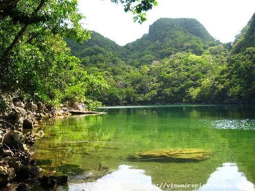
| Tayak Lagoon |
 |
| Tayak Lagoon |
The Tayak Lagoon
is a mystical place hidden from most people’s eyes and just seeing this wonder
of nature for you is well worth the trip.
 |
| Lahos Island |
Our Lady of Peace Grotto is located at the top of Caglago Mountain in Barangay Tabgon, Caramoan, Camarines Sur. It has 546 steps to the grotto leads to the 26-foot image of the Blessed Virgin Mary.
.jpg) |
| Lahos Island |
 |
| Our Lady of Peace |
 |
| Our Lady of Peace |
Caramoan is a first-class municipality in the province of Camarines Sur, Bicol Region, Philippines. It is located at the tip of the Caramoan Peninsula, a rugged place of land extending into the waters of the Maqueda Channel on the north and east and Lagonoy Gulf on the south. According to the 2010 census, it has a population of 44,945 people.
Geography
Caramoan is bounded on the north by the town of Garchitorena and the Philippine Sea of the Pacific Ocean; on the northeast by the island province of Catanduanes; on the south by Lagonoy Gulf; on the east by the Maqueda Channel and on the west by the municipality of Presentacion.
The municipality covers approximately 277.41 square kilometres (107.11 sq mi) with approximately 71 kilometres (44 mi) of irregular coastline surrounded by the vast ocean, bay, seas and swamps. It is approximately 500 kilometres (310 mi) from Metro Manila; 95 kilometres (59 mi) from the municipality of Pili, where the seat of the provincial government and the Naga Domestic Airport are located; and 110 kilometres (68 mi) east from Naga City, the heart of Bicol.
History
The name Caramoan has been officially used since 1619, the year it was named by a Spanish missionary friar, Francisco de la Cruz Y Oropesa. Fr. Oropesa penetrated the thick virgin forest of the Caramoan Peninsula and founded a small settlement in a place called Baluarte. This settlement was subsequently turned over to the administration of the Holy Bishopric in 1696.
Prior to the arrival of the Spaniards, it was determined that the place was once called Guta de Leche, which was given by Dutch traders who operated a gold mine in Lahuy Island and who frequented the area to trade with the natives. The name was perhaps derived from the milkdrop stalagmites found among the rocks of Guta Port. Upon the arrival of the Spaniards, the place came to be called "Carahan" for the sea turtle, which was at that time to be found in great number along the shores of the Peninsula.
No comments:
Post a Comment
What is in your mind?